The Polar Vortex and Sudden Stratospheric Warming: Why Late Winter 2027 Could Still Turn Cold
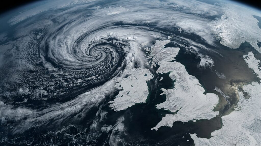
The stratospheric polar vortex is a ring of strong winds circling the Arctic about 10–50km up. When it’s strong, it locks cold air over the pole and the UK gets mild, wet, stormy weather. When it’s disrupted — a sudden stratospheric warming, or SSW — that cold air can spill south, and the UK’s most memorable cold spells have followed. El Niño winters raise SSW likelihood, and there’s an early signal of a January weakening this winter. That’s the genuine cold risk for 2026/27 — a late-winter snap, not a cold season.
This is the mechanism behind almost every significant UK cold spell of the last two decades, and it’s worth understanding properly, because it explains why “mild winter overall” and “disruptive freeze in February” are not contradictory statements.
What the polar vortex actually is
Two things get called the polar vortex, and conflating them causes most of the confusion.
The tropospheric polar vortex is a broad, semi-permanent feature of the lower atmosphere. It’s always there, and it isn’t newsworthy.
The stratospheric polar vortex (SPV) is the one that matters here. It forms each autumn as the Arctic goes dark and the stratosphere above the pole cools sharply, creating a strong temperature gradient with lower latitudes. That gradient drives a powerful band of westerly winds circling the pole, roughly 10 to 50 kilometres up. It strengthens through early winter, and breaks down naturally in spring.
Think of it as a wall of wind holding very cold air in place over the Arctic.
Why its strength decides what the UK gets
A strong SPV keeps that wall intact. The tropospheric jet stream tends to run strong and zonal — straight west-to-east across the Atlantic — steering low-pressure systems directly at the British Isles. Mild, wet, windy. The cold stays north.
There’s evidence a strong vortex actively increases storm risk. Research by University of Leeds and Met Office scientists into the February 2022 cluster of storms Dudley, Eunice and Franklin found that an unusually strong stratospheric polar vortex made it up to three times more likely that intense storms would affect the UK and northern Europe that month. Met Office science lead Jeff Knight described an intense stratospheric polar vortex as recognisable as a warning of increased risk of damaging storms.
A weak or disrupted SPV does the opposite. The wall breaks down, the jet stream buckles into a meandering pattern, high pressure can build to the north, and cold Arctic or continental air is free to spill southward into the UK.
Sudden stratospheric warming
An SSW is the dramatic version of that disruption. Large-scale atmospheric waves propagating up from the troposphere hit the vortex and slow it. In a major SSW, stratospheric temperatures over the pole can rise tens of degrees in a matter of days, and the vortex winds reverse from westerly to easterly.
The consequences take time to reach the surface. The signal propagates downward over roughly two to six weeks, which is why a cold spell often arrives well after the SSW itself. That downward lag is also what makes SSWs genuinely useful for forecasting — they offer several weeks of warning that the risk of a cold outbreak has risen.
An important caveat: not every SSW delivers UK cold. Roughly two-thirds are followed by a cold outbreak somewhere in the Northern Hemisphere mid-latitudes, but the cold doesn’t always land on Britain. It’s a loading of the dice, not a guarantee.
Why this winter specifically
Two independent reasons to pay attention.
El Niño raises SSW likelihood. Research has shown that the chance of an SSW occurring increases in El Niño winters relative to ENSO-neutral years, and this feature is reproduced in seasonal hindcasts. With NOAA giving a greater than 90% chance of a very strong El Niño for autumn and winter 2026–27, that’s a meaningful background shift.
There’s an early signal. Long-range data has shown a notable January weakening signal in the stratosphere for winter 2026/27, alongside several background drivers developing in a way that can increase the chance of a more dynamic winter pattern across the United States, Canada and Europe.
The shape of the winter this implies
Putting the two signals together gives a coherent, if unglamorous, picture:
- Autumn and early winter: El Niño’s enhanced subtropical jet favours mild, wet, windy and stormy — the Met Office’s stated expectation of a higher chance of milder, wetter and windier weather in this window. Our storm-proofing guide covers this.
- Late winter: raised SSW risk means a meaningful chance of a disruptive cold spell — sharp, memorable, and probably a few weeks rather than a season.
This is genuinely how several recent El Niño winters have played out, and it’s why our companion article declines to call it a cold winter while still telling you to prepare for cold.
How to follow it yourself
You don’t need a subscription. The things to watch:
- Stratospheric wind at 10hPa, 60°N — the standard metric. Freely published by NOAA and academic groups. A reversal to easterly defines a major SSW.
- Met Office long-range outlooks — updated regularly, with honest probabilistic language.
- Met Office weather warnings — the actionable layer once anything is imminent.
What to be sceptical of: any single ensemble member showing something dramatic. Large ensembles always contain extreme members; one is not a forecast.
What to actually do about it
The honest answer is that preparation for an SSW cold snap is the same as preparation for any cold snap, which is reassuring — you don’t need to predict it.
- Draught-proof. Cheapest and most effective winter measure available, and it works in every winter. Our draught-proofing guide covers it.
- Be able to heat one room properly. A cold snap is survivable and affordable if you can keep a single room genuinely warm — our one-room heating guide covers the options and their real running costs.
- Know your cold rooms now. Our room imbalance guide covers why one room runs cold and what fixes it.
- Check on vulnerable neighbours during any cold spell. Cold remains a larger cause of temperature-related mortality in England and Wales than heat.
- Have a plan for burst pipes. The most common household consequence of a sharp freeze, and largely preventable.
Frequently asked questions
Does a sudden stratospheric warming always mean UK snow?
No. Around two-thirds of SSWs are followed by a cold outbreak somewhere in the Northern Hemisphere mid-latitudes, but the cold can land on North America or Asia rather than Europe. It raises UK risk considerably; it doesn’t guarantee anything.
How long after an SSW does cold weather arrive?
Typically two to six weeks, as the signal propagates down from the stratosphere to the surface. That lag is precisely what makes SSWs valuable — they give forecasters several weeks of advance warning that risk has increased.
Is the polar vortex getting weaker because of climate change?
Genuinely an active area of research rather than a settled question. Some studies link Arctic sea ice loss to stratospheric vortex changes; others find weak or inconsistent signals. It’s a legitimate scientific debate, and anyone presenting it as settled in either direction is overstating the evidence.
Can a strong vortex be bad too?
Yes, just differently. A strong vortex favours a mild but very stormy pattern — the February 2022 research found a strong vortex made intense UK storms up to three times more likely. Neither state is benign; they simply deliver different problems.
Sources
- Met Office — Damaging cluster of UK winter storms driven by swirling polar vortex (Leeds/Met Office research; strong SPV made intense storms up to 3x more likely; Jeff Knight)
- Ineson et al., “Prediction of European Winter 2023/24: Influence of a Strong El Niño”, Atmospheric Science Letters (SSW likelihood in El Niño winters; citing Butler & Polvani 2011, Ineson et al. 2024, Scaife et al. 2016)
- Severe Weather Europe — Polar Vortex Warning Signs for Winter 2026/2027 (January weakening signal)
- NOAA Climate Prediction Center — ENSO Diagnostic Discussion
- Met Office — Sudden stratospheric warming
- ONS / BBC — Heat and cold related deaths in England and Wales
Related reading: our winter 2026/27 outlook and storm-proofing guide.
Related guides


Compare current prices, stock and reviews on portable air conditioners at Amazon UK. Prices and stock move fast in a heatwave, so it is worth checking before you commit.
Browse air conditioners →